Maps
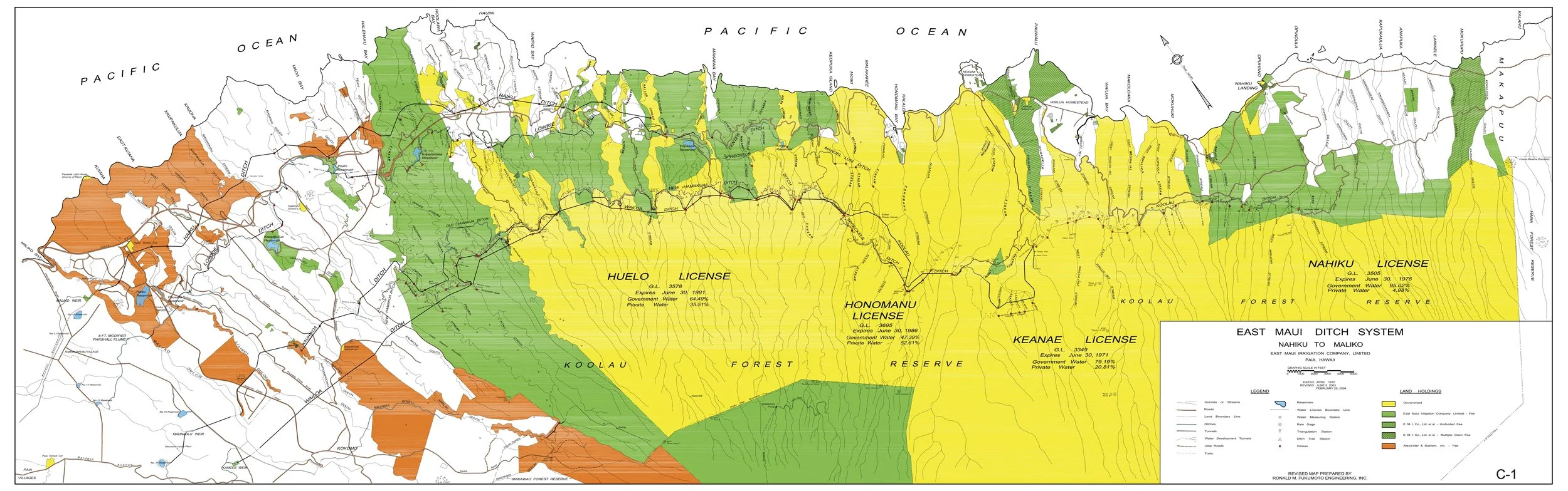
Map 1 - is a detailed view of the 33,000 acres of public watershed lands and 17,000 acres of Plantation controlled watershed lands and the streams and ditch systems that have drained the streams for over 100-years. The map spans from Maliko Gulch in Ha’iku to the end of the EMI ditch system in Nahiku.
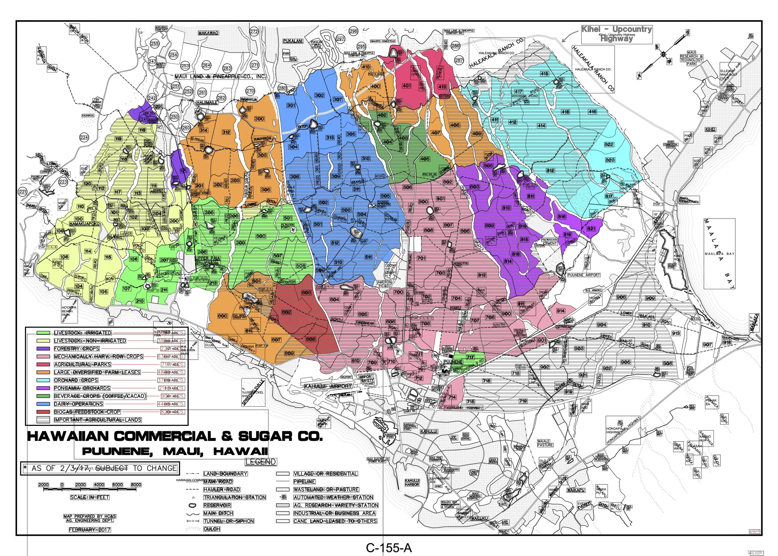
Map 2. A&B Fields map- from A&B’s 2018 presentation of their “diversified agriculture plan” to the state Land Board- along with plan to use around 80 mgd of water from East Maui streams. The map spans the former A&B plantation lands from Maliko Gulch to the edge of Kihei. It shows the internal "field numbers" of all A&B/ Mahi Pono fields as well as the location of theA&B/Mahi Pono ditches and reservoirs . This map also shows acolor-coded “suggested" planting plan. This plan was modified when the 36,-000 acres of A&B’s former sugar lands were sold to Canadian and California- based agri-business partnership, Mahi Pono. For example- only one area of 3,700-acres was proposed for “orchard crops” while much larger area of 6,367-acres was proposed for “Mechanicly Harvested Row Crops. “ Currently, Mahi Pono has only 124 acres planted in row crops/ around 400-acres planted in coffee and the vast majority of the 10,000 acres planted over the last five years are orchards of citrus trees. The original plantation field numbers remain the same and are handy to know, as they are referred to in many Mahi Pono reports.
Map 3.- Map of A&B/ Mahi Pono reservoir system- from the 2021 A&B/Mahi Pono Environmental Impact Statement ("EIS”) compiled to support the company’s request for 30 year leases from the state to divert East Maui water. No least has been granted.
Mahi Pono inheirited around 16 water storage reservoirs from the A&B-owned HC&S plantation lands. 13 of those have been used in recent years. Three of these reservoirs: numbers 23, 35 and 24 are lined. Reservoir capacity was originally designed for about 1 billion gallons.
Millions of gallons a day of east Maui stream water are sent to these reservoirs every day. Maui County by agreement has 6 mgd of east Maui stream water from East Maui irrigation’s Wailoa ditch deliver to its Kamole treatment plant and 1.5 mgd to the county’s Kula ag park EVERY DAY. Most days the county treatment plant needs no more than 3 mgd and the ag park needs about .7 mgd. The “Unused” portion of the water from Kamole plant is routed to reservoir 33 and from Ag park to reservoir 40. Both reservoirs are unlined. millions of gallons of water stored appear to be lost everyday to evaporation and seepage. No measurements are made and the state does not ask for accountability. Sierra Club legal filings contintinue to ask that this water have actual beneficial use, and not be wasted, or at least be stored in lined reservoirs. Mahi Pono/A&B have stated that the most used reservoirs are number 25 (capcity of 40 mg) , which takes most, then reservoir numbers 33, 90 (41 mg capacity) , 61 then 40 (capacity 62 mg) .

Map 4.- Map of location of EMI/ Mahi Pono water east Maui diversion ditches- from the beginning of the system in Nahiku to the terminus of the east Maui ditches in central Maui, near Kihei. A&B fields in the Waikapu and wailuku area do not use East Maui stream water, but have another set of ditches that bring water from the streams of Nā Wai ‘Ehā (not shown on this map)

Map 5.- Map of locations of A&B /Mahi Pono wells in central Maui area. Wells are listed by their official State Water Commission registration numbers. Mahi Pono refers to these wells by their plantation days numbers. The attached CWRM reporting form gives the official well number and the “plantation name” of the same well. A&B depended on their 15 wells to irrigate the sugar fields during times of low rainfall. Some wells are shallow “Maui skimming wells” built over 100 years ago.

